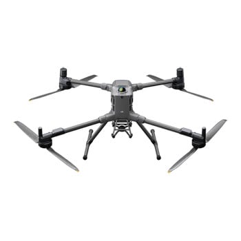
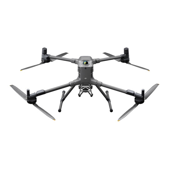
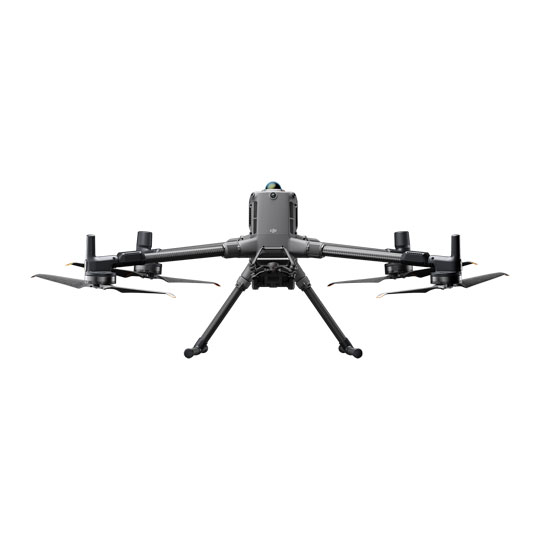
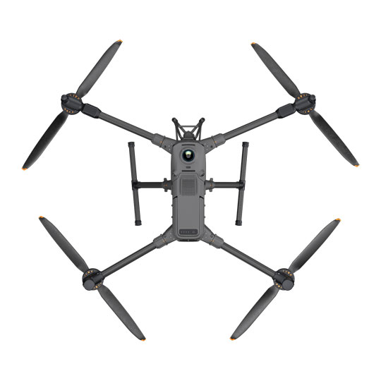


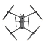
DJI Matrice 400 Enterprise Drone
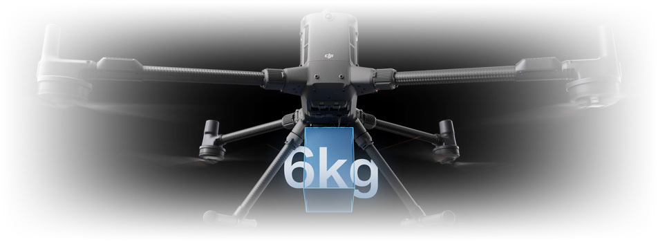
DJI Matrice 400 Enterprise Drone, 59min Flight Time, 6kg Payload Capacity, IP55, O4+ Enterprise Enhanced Transmission
Email me when the availability or price changes
Finance this product
- From £230.64 / month (APR 16.9%) for 48 months or 0% for 4 months
- With a 10% deposit from just £204.31 / month (APR 15.9%)
Suggested Alternatives
")
")
 DJI Matrice 300 RTK Universal Edition Professional Drone for Inspections, Rescue and Data CollectionDJI Matrice 300 RTK Universal Edition Drone (UK)
LN110020
No customer reviewCall for price
DJI Matrice 300 RTK Universal Edition Professional Drone for Inspections, Rescue and Data CollectionDJI Matrice 300 RTK Universal Edition Drone (UK)
LN110020
No customer reviewCall for price
 Enterprise Drone")
 Enterprise Drone")
 Enterprise Drone")
 Enterprise Drone")
 Enterprise Drone")
 Enterprise Drone")
DJI - 'Matrice 400'
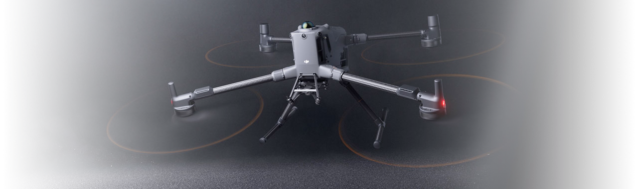
Engineered for Excellence, Designed for VersatilityThe DJI Matrice 400 is the enterprise flagship, long-endurance drone platform with power-line-level obstacle sensing. Boasting an impressive 59-minute flight time, payload capacity 6kg and integrated rotating LiDar and mmWave radar for power-line-level obstacle sensing. Supporting O4 Enterprise Enhanced Video Transmission and Airborne Relay Video Transmission (Refer to local laws and regulations for more information), ensuring safer handling and easier operations. Combining Smart Detection with visible and thermal imaging, AR projection, ship-based takeoff/landing, and advanced automation, the Matrice 400 excels in emergency response, power inspections, mapping, and AEC.

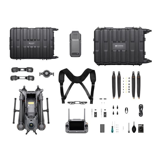
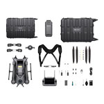
What's IncludedDJI Matrice 400 × 1
TB100 Intelligent Flight Battery × 1
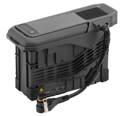
BS100 Intelligent Battery Station × 1
DJI RC Plus 2 Enterprise Enhanced × 1
DJI RC Plus 2 sub2G SDR Module × 1
DJI RC Plus 2 Strap and Bracket Kit × 1
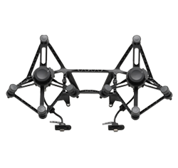
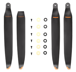
DJI Matrice 400 2510F Propeller × 1
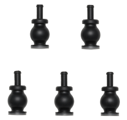
DJI Matrice 400 Gimbal Damper × 1
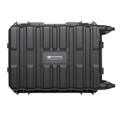
DJI Matrice 400 Carrying Case × 1
Rotating LiDAR Calibration Cover × 1
Front Propeller Holder × 1
Rear Propeller Holder × 1
USB-C to USB-C Data Cable × 1
WB37 Battery × 1
E-Port V2 Rubber Port Cover × 2
Rubber Plug Screws (2×2) × 4
Screws and Tools × 1
Cleaning Tools × 1
Extended Flight Time, High Speed Performance
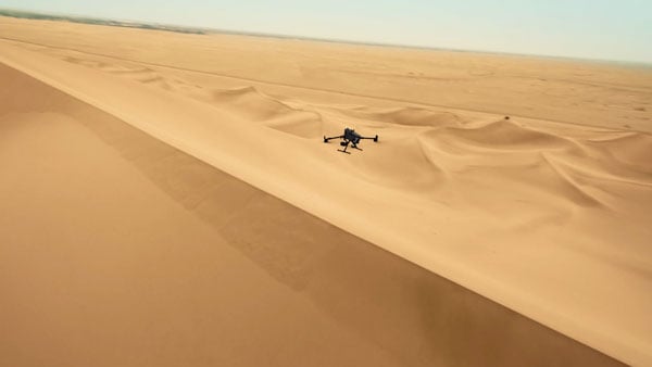
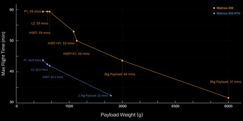
outstanding flight capabilitiesMatrice 400's flight capabilities are outstanding, offering up to 59 minutes of forward flight time even with a payload, and up to 53 minutes of hovering duration. These capabilities make it a reliable tool for long-duration and continuous operations such as search and rescue, firefighting, and large-scale mapping. It can also avoid large obstacles like buildings and mountains at flight speed of up to 25m/s.
Multi-Payload, Multi-Scene
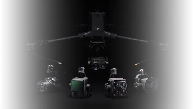
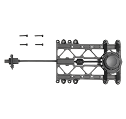
outstanding flight capabilitiesMatrice 400’s strong payload capacity allows it to easily meet the demands of a wide range of applications. With a maximum payload capacity of 6 kg [2], Matrice 400 supports seamless switching between a single downward gimbal [8] and a dual downward gimbal [8]. It also features a third gimbal connector on the underside for additional flexibility. The aircraft is equipped with 4 external E-Port V2 ports [7], enabling simultaneous mounting of up to 7 payloads.
Depending on the task, Matrice 400 can be equipped with the Zenmuse H30 Series, L2, P1, S1 Spotlight, V1 Speaker, Manifold 3, or third-party payloads, thereby expanding its capabilities and unlocking the full potential of the DJI ecosystem.
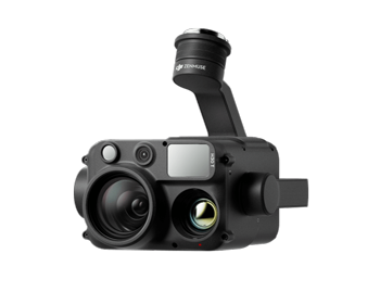
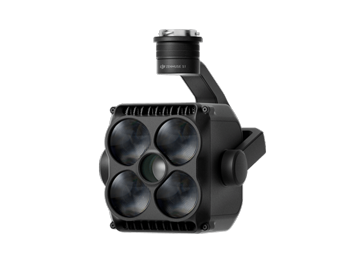
Zenmuse H30 SeriesThe Zenmuse H30 Series integrates five major modules—a wide-angle camera, a zoom camera, an infrared thermal camera, a laser range finder, and an NIR auxiliary light. Employing cutting-edge intelligent algorithms, it revolutionizes perception and imaging standards, transcending the limitations of day and night vision.
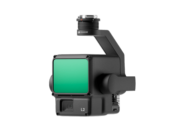
Zenmuse L2Zenmuse L2 integrates frame-based LiDAR, a self-developed high-accuracy IMU system, and a 4/3 CMOS RGB mapping camera, providing DJI multi-payload drone platform with more precise, efficient, and reliable geospatial data acquisition.
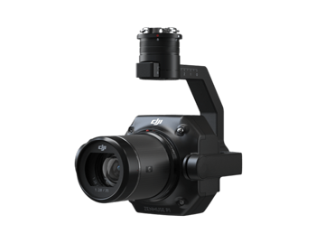
Zenmuse P1Zenmuse P1 integrates a full-frame sensor with interchangeable fixed-focus lenses on a 3-axis stabilized gimbal. Designed for photogrammetry flight missions, it takes efficiency and accuracy to a whole new level.
Zenmuse S1Zenmuse S1 is DJI's first spotlight designed for multi-payload drone platforms. Utilizing the LEP technology, it offers high brightness and long illumination distance, and supports multiple lighting modes. This makes it ideal for public safety, emergency rescue, inspection, and other nighttime operations.
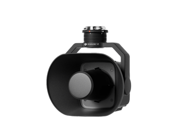
Zenmuse V1Zenmuse V1 is DJI's first loudspeaker designed for multi-payload drone platforms. It boasts high volume and long broadcast distance, and supports multiple broadcast modes, making it ideal for scenarios like public safety, emergency rescue, and more.

Manifold 3Manifold 3 packs an impressive 100 TOPS of computing power into a compact unit weighing about 120 g. It can be mounted onto Matrice 400 drone platform, optimizing efficiency across various operational missions with its robust processing.
Flight TimeEstimated the Matrice 400's flight time based on payload configuration.
Safe and Reliable Flight
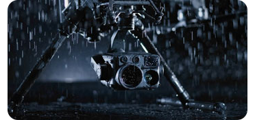
Built for Challenging ConditionsMatrice 400 has a protection rating of IP55 [9], allowing it to operate reliably in challenging conditions including heavy dust or rain. It also maintains stable performance across temperatures from -20° to 50° C (-4° to 122° F), delivering consistent results in both hot and cold conditions.
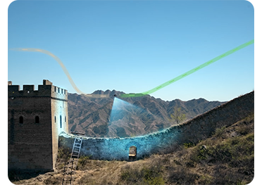
Power-Line-Level Obstacle Sensing[3]The Matrice 400's advanced obstacle sensing system integrates rotating LiDAR, high-precision mmWave radar, and full-color low-light fisheye vision sensors [13], pushing detection capabilities to unprecedented levels. The system detects even small obstacles like high-voltage power lines across mountainous terrain — even in darkness [3]. It can penetrate rain and fog to sense its surroundings, providing enhanced safety in challenging weather conditions.
Robust Video Transmission
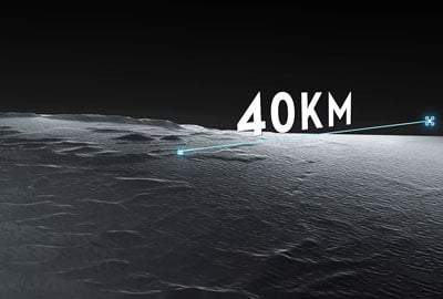
O4 Enterprise Enhanced Video Transmission SystemThanks to the ten-antenna system on the aircraft and the high-gain phased array antenna system on the remote controller, the O4 Enterprise Enhanced Video Transmission System can achieve image transmission up to 40 km [10].
Matrice 400 also supports the sub2G frequency band [5], and when equipped with two DJI Cellular Dongle 2 [11], it can automatically switch to the better available carrier network, providing a more stable signal even in urban interference environments or remote regions.
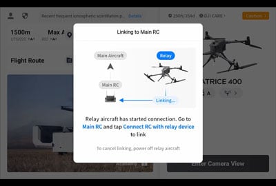
Airborne Relay Video Transmission [5]Matrice 400 has a built-in video transmission relay module. With this setup, one Matrice 400 can serve as a relay drone, flying high to provide relay signals for another Matrice 400 operating at a greater distance. This capability significantly extends the transmission range, making it ideal for search and rescue tasks as well as inspections in mountainous areas.
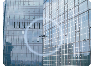
Aircraft Fusion PositioningThe omnidirectional sensing performance [12] brought by rotating LiDAR, high-precision mmWave radar, and full-color low-light fisheye vision sensors provides Matrice 400 with strong positioning capabilities. It can fly stably close to glass-facade buildings or wind turbine blades and safely return from building edges, mountain bases, or bridge sides even when the return point has not been updated.
Full-Colour Vision AssistThe four full-colour low-light fisheye vision sensors on the aircraft provide Full-Color Vision Assist [13] to ensure safer flight.
Enhanced Intelligence and Efficiency
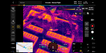
Smart Detection [14]With Zenmuse H30 Series' visible and thermal imaging, Matrice 400 can detect vehicles, vessels, and subjects during search and rescue operations or routine flights. It also supports switching to other models, enabling the expansion of application scenarios. Additionally, it supports high-res grid photos and features powerful tracking capabilities.
Smart AR Projection
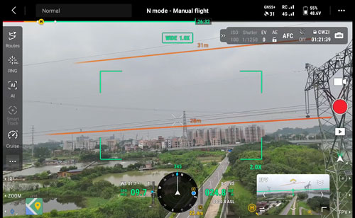
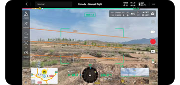
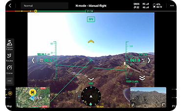
During tasks such as power grid inspection, the obstacle sensing system automatically detects frontal wire obstacles [3] and displays easily recognizable AR lines on the remote controller’s screen, making the surrounding environment clear at a glance and ensuring safer flight.

When operating during the day or night in urban regions, the remote controller can display the names of buildings and landmarks in real-time, marking core roads with prominent lines.
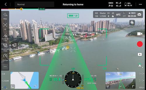
Real-time route preview is available for the drone during RTH, obstacle sensing, and FlyTo operations. During landing, the AR Aircraft Shadow can be displayed to help operators confirm the landing location.

Without modeling, you can mark points on the remote controller screen to obtain subject locations, draw lines to measure distances between multiple points, and outline areas to calculate their size. Measurement results can be synchronized to the DJI FlightHub 2 to enhance team efficiency.
Real-Time Terrain FollowMatrice 400 supports Real-Time Terrain Follow flight in any horizontal direction [15]. This feature can be enabled during both manual flight and automated flight routes, ensuring stable relative height to the ground.
During large-scale search and rescue operations, the size of ground subjects can be kept consistent on the remote controller screen, reducing the need for frequent zoom adjustments and improving efficiency. During mapping missions, a consistent ground sampling distance (GSD) can be maintained to obtain high-precision mapping data.
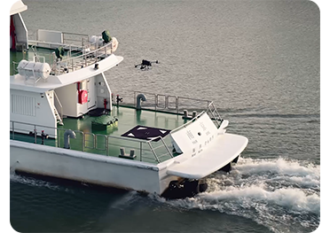
Takeoff and Landing on Ships [16]To address the needs of offshore operations such as maritime patrol and wind turbine inspection, Matrice 400 is equipped with the capability to take off from and land on ships, supporting takeoff from stationary vessels and landing on moving vessels. By detecting landing point patterns on the deck, it can achieve safe and precise landings.
Intelligent Flight Modes
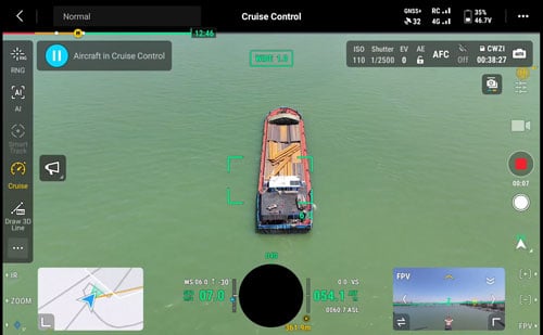
Activate cruise control mode to pilot the drone in a specific direction without constantly pressing the control sticks, making long-distance flights or linear inspections easier.
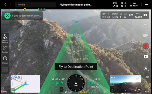
In emergencies or disasters, the drone can automatically adjust its flight path and speed based on the surrounding environment, allowing it to reach a designated location without manual adjustments.
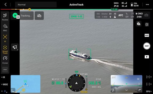
Smart Track allows for precise subject positioning and automatic zoom adjustments, allowing you to switch between subjects easily. It can automatically reacquire a subject even if obscured briefly.
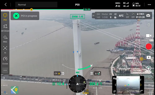
POI enables continuous observation and 3D modeling of buildings while orbiting a designated area, greatly enhancing the efficiency of fixed-point observation and modeling tasks.
Easier Automated Operations
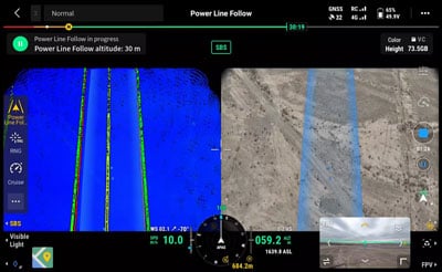
Power Line Follow with Zenmuse L2When equipped with the L2 LiDAR system, Matrice 400 can perform automated power transmission and distribution line following flights. It uses the rotating LiDAR to detect obstacles in real time and automatically bypasses crossing lines.
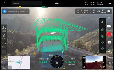
Slope Route & Geometric RouteMatrice 400 supports the planning and execution of slope and geometric routes via DJI Pilot 2 or DJI FlightHub 2. Whether conducting detailed aerial surveys of building facades, slopes, or other inclined surfaces, or collecting mapping data of individual buildings or structures, Matrice 400 can quickly plan slope or geometric routes to efficiently acquire high-precision data.
Comprehensive Accessories
Software Designed for Industries
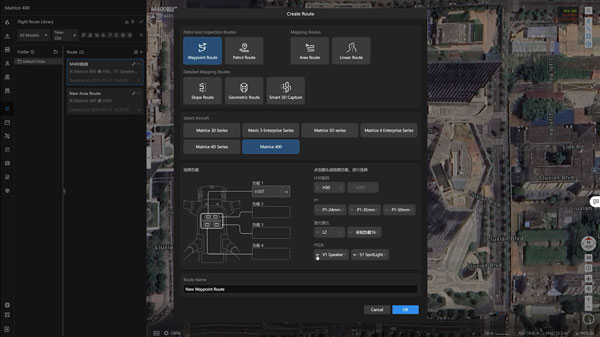
Specifically for the Matrice 400, DJI FlightHub 2 has been upgraded to enable cloud-based remote control, allowing operators to control the aircraft's flight attitude and official payloads, as well as to perform remote takeoff, landing, and Live Flight Controls. In addition, it supports a wide range of flight route planning functions, including slope routes, geometric routes, and other advanced route types. During multi-drone operations, operators can remotely synchronize and display multiple livestreams across screens, creating a new, efficient air-ground integrated operation experience.
* Users who purchase Matrice 400 and bind it to FlightHub 2 upon activation will receive allocated live streaming minutes, map imagery quotas, and cloud storage space.
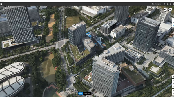
DJI Terra is a 3D model reconstruction software that has photogrammetry as its core technology. It supports accurate and efficient 2D and 3D reconstruction using visible light data, as well as point cloud data reconstruction and processing with DJI Zenmuse L2. DJI Terra is an ideal match for DJI Matrice 400 and its payloads. It works in conjunction to build a complete application solution that caters to vertical scenarios such as land surveying and mapping, power line inspection, emergency response, construction, and forestry.
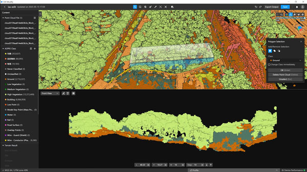
DJI Modify provides intelligent 3D mesh and point cloud model editing. When paired with the Matrice 400 and DJI Terra, it can create an integrated solution covering aerial surveying, modeling, model repair, and sharing.
Open Developer Ecosystem
Intelligent Algorithm DeveloperProvides the necessary model training tools and third-party developer certification process to access onboard computing capability, helping to expand new application fields for drones.
PSDKThe newly upgraded E-Port V2 supports USB 3.0 high-speed payload communication and delivers up to 120 watts of power per port. The E4 port of the E-Port V2 can be expanded into four payload ports via the E-Port Hub expansion plate, unlocking broader application scenarios and greater potential for the Matrice 400.
MSDKMobile SDK 5 simplifies the development of apps to control the Matrice 400. It comes with fully open-source, production-level code samples with core modules adapted from DJI Pilot 2, guaranteeing high reliability.
Cloud APIWith DJI Pilot 2's built-in Cloud API (MQTT-based protocol), you can directly connect the Matrice 400 to third-party cloud platforms. Access the drone's hardware, video live-stream, and photo data without having to develop an app.
Open Data AccessDevelopers can leverage payload, LiDAR, mmWave radar, and vision sensor data interfaces to build innovative applications and expand the DJI ecosystem.
User Data Security
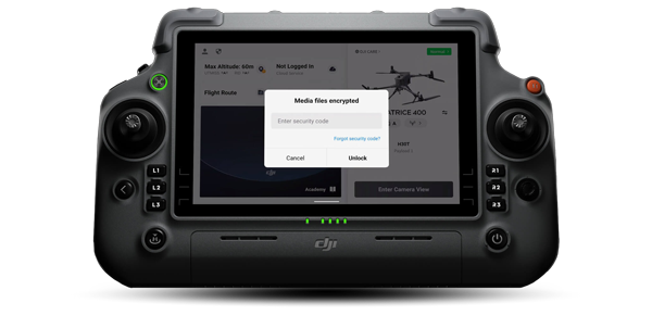

Media Data Encryption

Local Data Mode

One-Tap Clear Logs

AES-256 Video Transmission Encryption

Cloud API
Drone Laws, Training and Limitations
Registration RequiredRegister via the CAA website. If you have already registered it is mandatory to attach your Operator ID to your UAS/Drone.
LimitationsCAA Limitation for all UAS/Drones flights in UK Airspace Max Operating Height 120m/400ft and Maximum Operating Distance of 500m/visual line of site.
Open Category, A1 SubcategoryWithout an additional training course you can fly in the Open Category A1 subcategory (fly over people) this means:
• You may fly over people but not over crowds.
• If you want to fly in the A1 Transitional subcategory an A2 CofC is required.
• The 1:1 rule should be observed when flying close to uninvolved people.
Open Category, A2/A3 SubcategoryWithout a training course you can only fly in the Open Category’s A2/A3 subcategory (fly far from people), this means:
• No uninvolved people present within the area of flight.
• No flight within 150m horizontally of residential, commercial, industrial, and recreational areas.
Additional InformationFor more information about Drone Rules & Requirements please read HERE or contact Scan Pro Video for further information on Training Requirements.
Notes:* Always check and strictly abide by local laws and regulations before flying.
** All data on this page was collected with a production model of DJI Matrice 400 in a controlled test environment. Actual experience may vary depending on the environment, usage, and firmware version.
*** All videos and photos on this page were shot in strict compliance with local laws and regulations. Demos, including wildlife, were shot from a safe distance and are used for reference only. Please observe local laws and regulations and ensure the aircraft has obtained relevant certifications before flying.
**** Before use, Matrice 400 must be activated via the DJI Pilot 2 app.
1. Measured with the aircraft flying forward at a constant speed of 10 m/s in a windless environment at sea level, carrying only the H30T (total weight 10,670 g), and from 100% battery level until 0%. Data is for reference only. Actual experience may vary depending on the environment, usage, and firmware version.
2. The 6 kg payload is measured at the third gimbal connector under sea level conditions. Payload capacity decreases as altitude increases. For details, refer to the official user manual.
3. Power line obstacle sensing capability: When directly facing a transmission line (21.6 mm steel-core aluminum stranded wire), obstacle sensing is supported at speeds up to 25 m/s. When both transmission lines (21.6 mm steel-core aluminum stranded wire) and distribution lines (12 mm steel-core aluminum stranded wire) are present, obstacle sensing is supported at speeds up to 17 m/s. Obstacle sensing performance may vary depending on environmental conditions (such as cloud, fog, rain, or snow), as well as the material, position, and shape of the target object. Due to the limitations of the safety system, the aircraft cannot actively avoid fast-moving objects; please fly with caution in such environments. Refer to the user manual for more information. The mmWave radar function is unavailable in some countries/regions.
4. This feature is unavailable in countries or regions without 5GHz frequency support. Refer to local laws and regulations for more information.
5. Operating frequency allowed varies among countries and regions. Refer to local laws and regulations for more information.
6. Measured with the aircraft hovering in a windless environment at sea level, carrying only the H30T (total weight 10,670 g), and from 100% battery level until 0%. Data is for reference only. Actual usage time may vary depending on the flight mode, accessories, and environment.
7. The E4 port of E-Port V2 can be expanded into four payload ports via the E-Port Hub expansion plate. For more detailed information, visit https://developer.dji.com/payload-sdk to learn more.
8. Sold separately.
9. Please follow the requirements stated in the IP55 protection rating instructions. Measured in a controlled environment. The IP rating is not permanently effective and may decrease due to product wear and tear.
10. Measured with FCC compliance in an unobstructed environment with low interference at a flight altitude of approximately 120 m. Data is for reference only. During your flight, please pay attention to reminders in the app.
11. To use 4G Enhanced Transmission, the remote controller must be equipped with the DJI Cellular Dongle 2 (sold separately) or connected to the internet via Wi-Fi. This service is not available in some countries and regions. Please consult your local dealer for details.
12. There are certain blind areas of visual sensing and infrared sensing. Positioning and obstacle-sensing performance may be affected by the flight environment and obstacle characteristics. Please fly with caution.
13. When ambient light is below 12 lux, the visual sensor switches to black-and-white mode.
14. Zenmuse H30 Series required.
15. DJI Pilot 2 required.
16. It is recommended to use the feature when the ship speed is below 10 knots and the wind speed is below 5 m/s; exercise caution in other environments. It is recommended to reserve a 3 m × 3 m takeoff and landing space on the deck. Standard landing point pattern files are available on the download page.
17. The following accessories are all compatible with Matrice 400.
18. Charging time is measured based on a 220-volt voltage.
19. Measured in a controlled environment. Results may vary depending on the environment, actual use, and firmware version.
20. Service offerings may vary by country or region. For details, please consult your local dealer. Free Repairs: Get free repairs within the coverage scope and amount; Coverage for Your Whole Fleet: Shared coverage can be extended to other DJI Enterprise devices bound to DJI Care Enterprise Plus within the same time period (30 calendar days) after the first activation and binding; Free Shipping: Available in regions covered by DJI Care Enterprise. Users are responsible for additional costs including logistics and customs duties incurred beyond the scope of coverage. The official extended warranty covers the following components: aircraft body, intelligent battery station, remote controller, single downward gimbal module, dual downward gimbal module, and third gimbal connector.
PayPal Credit
| Monthly Payment: | £741.09 |
| Instalment Rate: | 16.9% p.a. (fixed) |
| Cost of purchase: | £8,179.99 |
| Total inc. interest: | £8,892.99 |
| Monthly Payment: | £399.42 |
| Instalment Rate: | 16.9% p.a. (fixed) |
| Cost of purchase: | £8,179.99 |
| Total inc. interest: | £9,585.88 |
| Monthly Payment: | £286.45 |
| Instalment Rate: | 16.9% p.a. (fixed) |
| Cost of purchase: | £8,179.99 |
| Total inc. interest: | £10,311.86 |
| Monthly Payment: | £230.64 |
| Instalment Rate: | 16.9% p.a. (fixed) |
| Cost of purchase: | £8,179.99 |
| Total inc. interest: | £11,070.67 |
| Example | |
| Minimum Spend: | £99 |
| Instalment Rate: | N/A |
| Cost of purchase: | £99 |
| Total inc. interest: | £99 |
Representative Example:
Purchase Rate: 23.9% p.a. (variable)
Representative: 23.9% APR (variable)
Assumed Credit Limit: £1,200
Subject to status. Terms and Conditions apply.