
Earth Systems Lab 2024 - SAR-FM: A Foundation Model for SAR
Earth Systems Lab 2024
SAR-FM: A Foundation Model for SAR
Published 20 JUNE 2025
Earth Systems Lab (ESL) by FDL Europe, applies AI technologies to space science, to push the frontiers of research and develop new tools to help solve some of the biggest challenges that humanity faces. These include the effects of climate change, predicting space weather, improving disaster response and identifying meteorites that could hold the key to the history of our universe.
FDL Europe is a public-private partnership with the European Space Agency (ESA) and Trillium Technologies. It works with commercial partners such as Scan, NVIDIA, IBM, Google, Airbus amongst others to provide expertise and the computing resources necessary for rapid experimentation and iteration in data intensive areas.
ESL 2024 was a research sprint hosted by the University of Oxford, taking place over a period of eight weeks in autumn 2024. The interdisciplinary teams address tightly defined problems and the format encourages rapid iteration and prototyping to create meaningful outputs to the space program and humanity.

Project Background
Although large amounts of satellite imagery are available globally, the task of manually labeling this data for machine learning applications is both time-consuming and expensive. Many regions, especially in developing countries, suffer from an imbalance in data availability. For example, regions such as the United States and Europe benefit from vast amounts of labeled satellite data, while parts of Africa, South America, and Asia remain underrepresented in Earth observation (EO) datasets. This imbalance in data availability makes it difficult to develop accurate, region-specific EO models, which are crucial for tasks such as vegetation monitoring, urban growth tracking and environmental assessments. However, Earth observation foundation models (EO-FMs), which have been pre-trained on large datasets from data-rich regions, have the potential to perform well in low-data environments by transferring knowledge.
The challenge of generalising an FM across spatial regions is inherently complex due to the vast differences in environmental features between regions. For instance, vegetation in tropical regions such as Colombia behaves differently from vegetation in arid regions or mountainous regions. A model trained on data from one region may fail to capture the specific characteristics of vegetation, climate and topography when applied to another region, leading to poor performance. The difficulty in generalising across regions is further exacerbated by the variability in the spectral characteristics of satellite imagery, which can differ based on the type of sensor used. For example, SAR data from the Sentinel 1 satellite and optical data from the Sentinel 2 satellite have different properties, making it challenging for a model to perform equally well on both types of data.
Project Approach
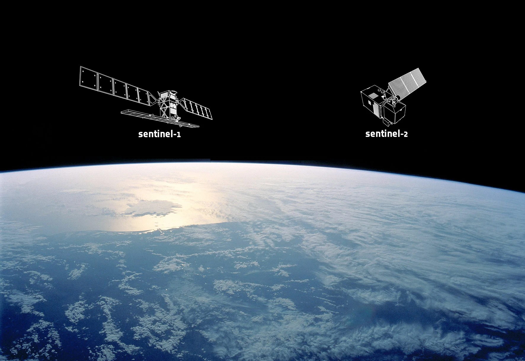
The ESL team’s research was focused on utilising satellite imagery from the Sentinel 1 and Sentinel 2 missions, which are part of the European Space Agency’s (ESA) Copernicus program. Sentinel 1 (S1) provides SAR data, which is particularly useful for monitoring changes in surface structure, while Sentinel 2 (S2) provides optical data, capturing a wide range of spectral information. These two data types complement each other, with Sentinel 1 being well-suited for tasks involving surface structure analysis, and Sentinel 2 being ideal for analysing vegetation, water bodies, and built-up areas. Satellite imagery was selected for numerous areas of interest (AOIs) - three areas in the US, Europe and China that were typically rich on labels that could be used to train models; and eight target AOIs - Colombia, Peru, Kenya, India, Spain, Germany, California and Texas with limited data. The team used chips of size 512 × 512 pixels which, at Sentinel’s resolution of 10m / pixels, corresponds to a spatial resolution of 5.12km × 5.12km, or 26.2km2, as shown in the table below.
| AOI | Million km² | Number of Chips | Landmass Coverage |
|---|---|---|---|
| US | 7.9 | 30,418 | 10% |
| Europe | 5.5 | 35,936 | 17% |
| China | 9.4 | 35,934 | 10% |
| Columbia | 1.2 | 4,222 | 10% |
| Peru | 1.3 | 4,860 | 10% |
| India | 3.1 | 11,875 | 10% |
| Kenya | 0.6 | 2,228 | 10% |
| Spain | 0.5 | 1,905 | 10% |
| Germany | 0.5 | 6,556 | 48% |
| California | 0.4 | 1,589 | 10% |
| Texas | 0.7 | 2,620 | 10% |
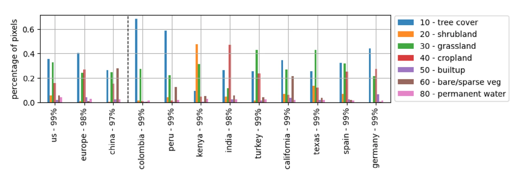
These datasets were complemented by information from the ESA World Cover (ESAWC) product, showing distributions of seven selected landcover classes for each AOI - tree cover, cropland, shrubland, grassland, bare / sparse vegetation, built-up areas and permanent water. These are illustrated in the graph below, where the percentage indicates how much of the AOI landmass is covered by these seven classes.
The team’s experiments were centred around fast adaptation and large-scale ablation study, to determine the contribution of a component to an AI system by removing the component, and then analysing the resultant performance of the system) of existing EO-FMs, focusing on how different pre-trained models perform when applied to various downstream tasks. They evaluated eight different EO-FMs, selected based on their relevance to EO tasks and their ability to handle large-scale satellite data effectively. Each model was pre-trained on global S1 and S2 data, using various architectural designs, including Vision Transformers (ViTs) and Masked Autoencoders (MAEs), and evaluated against the land cover classification task, where the goal was to predict the percentage of each landcover class within a given satellite image chip. These EO-FMs have shown promise in addressing these challenges through their pre-trained representations, although conventional fine-tuning methods remain computationally expensive and time-consuming, often requiring substantial GPU resources and large amounts of labeled data. To overcome these limitations, the team proposed a more efficient approach to EO-FM adaptation using the parameter-efficient Low-Rank Adaptation (LoRA) fine-tuning technique - which works by adding lightweight pieces to the original model, as opposed to changing the entire model - with a view to enhance both training speed and model performance.
Project Results
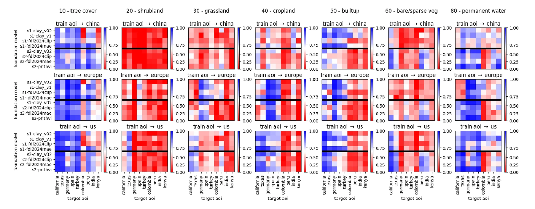
The team performed two ablation studies - firstly by using the three large AOIs for training models, and testing on target AOIs; and secondly, by using part of the data in the target AOIs for training, and testing on the remaining target AOI data. This resulted in around 18,000 models when using external AOIs for training, and around 7,000 models when splitting target AOIs for train and test. Each experiment was repeated 20 times, resampling the train and test data each time and reporting the mean and standard deviation of the metric, to result in a total of some 500,000 trained models. The below diagram shows the results of these experiments for each of the eight EO-FMs against the seven classifications of lancer for each AOI. Bluer positions represent greater correlation between predictions and targets, with redder positions representing worse correlation. The black horizontal line splits indicate data derived from S1 (top) and S2 (bottom).
These plots showed tree cover and permanent water exhibited reasonable generalisability to non-US and non-European AOIs, however, models for permanent water trained in Europe seem to show better correlation in California and Texas, but only if data from S2 was used. Other results proved very AOI specific - cropland showed some signal when transferred between the US, Europe and Turkey; and models trained in China applied well in India. The team believed this may be due to the inherent differences between AOIs where classes probably gather a large variety of land features - for example, crops of palm trees look very different from crops of soy. Shrubland showed very low performance and no spatial generalisability at all and grassland had limited signal within the US and Europe. The team also observed some results that seemed inherently dependent on the sensor. For instance, generalisability in Peru and India for bare / sparse vegetation occurred when using S2 FMs regardless where the models were trained, and buildup seems more generalisable with S1 FMs (bluer above the black horizontal line), which was in line with the expected interaction of a SAR signal with man-made objects.
As previously mentioned, to address adaptability of the eight EO-FMs, the team used a LoRA fine-tuning experiment where numerous ranks (r-8, r64, r-256, r-512 and r-1024) were applied to the base model. The rank of a model represents the maximum number of linearly independent rows or columns in the model - the higher the rank, the more parameters in the model and the more computational power will be required. They found LoRA fine-tuning demonstrated superior performance across all rank values, but at the cost of increased GPU memory usage and trainable parameters. However, the performance uplift was not linear, with rank 256 achieving the best overall performance, with an accuracy of 94.29%.
Conclusions
The team explored innovative approaches to enhancing the adaptability and efficiency of Earth Observation Foundation Models (EO-FMs) for critical tasks such as flood detection. The integration of Synthetic Aperture Radar (SAR) data, coupled with advancements in machine learning techniques like Low-Rank Adaptation (LoRA), has demonstrated significant potential in improving the performance of EO-FMs, particularly when applied to regions with limited labeled data. The experiments conducted across diverse AOIs showed that models trained on data-rich regions can generalise to regions with sparse labeled data to varying degrees, depending on the task and the type of satellite data used. The use of LoRA fine-tuning proved to be particularly effective, allowing for faster adaptation of models without sacrificing performance, as demonstrated by the superior results.
You can learn more about Earth Systems Lab 2024 research and this SAR-FM: A Foundation Model for SAR project by visiting the ESL 2024 RESULTS PAGE, where a summary, poster and full technical memorandum can be viewed and downloaded.
The Scan Partnership
Scan is a major supporter of ESL 2024 and FDL Europe, building on its participation in the previous four years events. As an NVIDIA Elite Solution Provider Scan contributes multiple DGX supercomputers in order to facilitate much of the machine learning and deep learning development and training required during the research sprint period.
Project Wins
Demonstration that integration of SAR data into exiting EO-FMs showed improved performance in identifying landcover classes
Indications that LoRA fine-tuning techniques can help the adaptability of EO-FMs without sacrificing performance
Time savings generated during eight-week research sprint due to access to GPU-accelerated DGX systems

James Parr
Founder, FDL / CEO, Trillium Technologies
“FDL has established an impressive success rate for applied AI research output at an exceptional pace. Research outcomes are regularly accepted to respected journals, presented at scientific conferences and have been deployed on NASA and ESA initiatives - and in space.”

Dan Parkinson
Director of Collaboration, Scan
“We are proud to be continuing our work with FDL and NVIDIA to support the ESL 2024 event for the fifth year running. It is a huge privilege to be associated with such ground-breaking research efforts in light of the challenges we all face when it comes to life-changing events like climate change and extreme weather.”
Speak to an expert
You’ve seen how Scan continues to help the Earth Systems Lab and FDL Europe further its research into the climate change and space. Contact our expert AI team to discuss your project requirements.
Related content
View more case studies
FDL Europe — Earth Systems Lab
Discover more about how Earth Systems Lab applies AI technologies to space science.
Read More